
GTA 6 Interactive Map of Leonida — Vice City and Every Known Location
Explore the interactive map of Leonida from Grand Theft Auto VI — browse landmarks, districts, characters and easter eggs across Vice City and beyond. Search places, filter by region or category, and save entries. Map references are approximate; unresolved positions remain searchable. Select any of the five counties, change map styles and layers, or share the current view.
About the GTA 6 Map of Leonida
What is official?
The default basemap is Rockstar’s printed Leonida map. Named landmarks are marked directly on that artwork; additional community positions and shaded county areas are approximate. YANIS and SVG remain available in Layers. Source review: .
The latest review covers 161 named places, landmarks and routes on Rockstar’s printed Leonida map, alongside Rockstar’s region and character profiles and the Launch Gallery. Choose “Reviewed Rockstar sources” in Filters to see entries with inspected receipts. Towns, islands, waterways, districts and numbered roads are searchable by their printed names.
Explore 311 catalogued entries, with 243 reviewed catalogue references on Rockstar’s printed map of Leonida, the Florida-inspired state of Grand Theft Auto VI — from Vice City out to the Keys. Search the full catalogue, filter by county or category, and save places to revisit. Locations without a defensible position stay searchable.
Select a county name to explore its estimated extent and browse its locations. The layers control switches between Rockstar’s official map, YANIS v17, Clean SVG and the earlier illustrations, and toggles estimated county areas, clickable labels, place markers and coordinate readouts. Share a map view to preserve its camera position, selected county and layers. County names appear on Rockstar’s printed map; our shaded county extents are estimates.
Catalogue positions on the default map: 70 locations, 68 natural features, 53 businesses, 16 transport locations, 11 hotels, 8 industry, 8 activities, 4 services, 3 nightlife venues, 2 residential. Area markers are representative centres, not addresses or boundaries. Even a confirmed place can have an unresolved position.
Counties of Leonida
- Vice-Dale County — Vice City, Vice Beach and the bay islands, out to the airport and Hamlet — Rockstar’s modern take on Miami-Dade.
- Mariana County — the Grassrivers wetlands, the Gulf towns of Watson Bay and Capri, and the Leonida Keys.
- Kelly County — the Gulf coast around Port Gellhorn and its raceway, and the sugar country around Ambrosia.
- Leonard County — north of Vice City, from Lake Leonida to the Atlantic beaches of Waning Sands.
- Lummox County — the mountainous north, with Mount Kalaga National Park.
Vice City districts
- Ocean Beach — the world-famous beachfront, with a personal garage a stone’s throw from the sand.
- Washington Beach — where the Ultimate Edition’s boat is docked.
- Stockyard — home to the Stock 305 streetwear store and Electric Fang Tattoo.
- Southside — where the PTT Youngin$ Illegal Goods Store sits.
Places in the atlas
Browse the linked location records. Map references include reviewed artwork anchors and community estimates; unresolved places remain in search without a pin.
Vice-Dale County
- 7th Avenue GaragePosition unresolved
- A1 Fashions
- Ajax Gym
- Alpha Sports
- Atlantic Court GaragePosition unresolved
- Atlantis Hotel
- Balsero
- Bayside
- Boardwalk Hotel
- Bobby Hurricane's
- Bohemia
- Bonita Court GaragePosition unresolved
- Boone Speedway
- Catalan Bay
- Catalan BoulevardPosition unresolved
- Catalan Key
- Catalyst Realty
- Copyshop
- Cordelia Hotel
- Corsair Key
- Crosstown
- Crosstown GaragePosition unresolved
- Dalton Island
- Decor District
- Diamond Dawgs
- Diangelo
- Dominion Hotel
- Downtown Vice City
- Effluvia
- EkanfinakaPosition unresolved
- Electric Fang Tattoo
- Electrotoke
- Firefly Plaza
- Frills & Fancy
- Galina Ballet Opera House
- Glazin' Glory
- Gloriana Key
- Go Postal Office
- Haitian-American Cultural CenterPosition unresolved
- Hamlet
- Hamlet Water Tower
- Hobbs Milford
- Hoodwinks BarPosition unresolved
- Hotel Dixon
- Hotel Valetta
- Interstate 397
- Jack of HeartsPosition unresolved
- Jeudy's Food Depot
- Josefina Perfect Image
- Joyería Empeños
- Juxta Gallery
- La Perle
- La Perle Caribbean MarketPosition unresolved
- Leaf Links
- Leonida PenitentiaryPosition unresolved
- Leonida State Route 10Position unresolved
- Lickety Split
- Little Cuba
- Mami's Grocery Market
- Megamundo
- National Coast Guard Base
- Neptune HotelPosition unresolved
- NINE1NINE
- Ocean Beach
- Ocean Beach garagePosition unresolved
- Ocean Beach Pharmacy
- Ocean View Hotel
- Only Raw RecordsPosition unresolved
- Palaestra Tower
- Paño Rojo
- Papasco's
- Peacock Bay
- Peewees
- Perkins Deli
- Pharaoh
- Phil's Ammu-Nation
- Port Vice City
- PTT Youngin$ Illegal Goods Store
- Rialto Islands
- Rideout CustomsPosition unresolved
- Rockridge
- Royals
- Sahara Arena
- Salton
- Sandeep Plaza
- Sara's Unisex SalonPosition unresolved
- Seahorse Hotel
- Seven Seas Seafood
- Shore DrivePosition unresolved
- ShorelinePosition unresolved
- Simon's Tires
- Sinfrontera National BankPosition unresolved
- South Vice CityPosition unresolved
- Southside
- Starfish Island
- Stock 305
- Stockyard
- SW 9th AvenuePosition unresolved
- Tequesta
- Tequesta Retreat
- The Amalfi
- The Anderson
- The Fence
- The Flamingrill
- Third Eye
- Thompson Court GaragePosition unresolved
- Tisha-WockaPosition unresolved
- U.S. Route 3Position unresolved
- Vice Beach
- Vice Beach Police Department
- Vice City
- Vice City Arts CenterPosition unresolved
- Vice City International Airport
- Vice City Oceanarium
- Vice City Sign
- Vice Museum of Art
- Vice-Dale County
- Vice-Dale County Road 561Position unresolved
- Vicycle
- Video Forever
- Void
- Washington Beach
- What's Cooking
- Zeke's Gadgets
Kelly County
- Allied Crystal Sugar Refinery
- Ambrosia
- Ambrosia CountyPosition unresolved
- Ambrosia Police Department
- Ambrosia Raceway Park
- Bocamar Bridge
- Borrachero Sound
- Burnout Scooters
- Crossroad Park Minimall
- Crude Islands
- Delights CabaretPosition unresolved
- Draper Bay
- Draper Island
- Emerald Springs
- Gellhorn International Raceway
- Gellhorn Roadhouse
- Hank's WafflesPosition unresolved
- Happy Nails
- Interstate 404
- Kelly County
- Leith River
- Leonida State Route 9Position unresolved
- Manifest Canyon
- Mitchell Auto CenterPosition unresolved
- MoneyShift
- Port Gellhorn
- Port Gellhorn Pawn & GunPosition unresolved
- Port Gellhorn Station GaragePosition unresolved
- Sandbars
- Starlet Motel
- Store n' BoltPosition unresolved
- The Thirsty WolfPosition unresolved
- Thrillbilly Mud Club
- U.S. Route 2Position unresolved
- U.S. Route 35
- Uncle Jack's Liquor
- Watkins Auto Parts
- Whiz
- Wild Hog Point
- Wyatt MotorsPosition unresolved
Mariana County
- Abismo Key
- Animal Hospital of Key LentoPosition unresolved
- Belpoint
- Bite House
- Bobcat Key
- Brian's boat yard
- Capri
- Chip's Body Shop
- Cottonmouth Lake
- East KeyPosition unresolved
- Gambit Bay
- Goose Key
- Grassrivers
- Gullet Marsh
- Key Lento
- Leonida Keys
- Mariana County
- Maroon Key
- Mile Zero Air Station
- Paradise Garage
- Pelican River
- Pelican Valley
- Permit Keys
- Riquezas Keys
- Shoeless Keys
- Southwind
- Sunrise RV ParkPosition unresolved
- The Rusty Anchor
- Vela Rota Driver GaragePosition unresolved
- Watson Bay
- Wonder Whale
Lummox County
Leonard County
- Belville
- Frontier Adventure GolfPosition unresolved
- Interstate 97
- Lake Leonida
- Leonard County
- Little Hardin Island
- One-Eyed Willie's Mod ShopPosition unresolved
- Persistence Road GaragePosition unresolved
- Vinewood Beach
- Waning Sands
Leonida
- Flamingo IslandPosition unresolved
- Leonida Marine CenterPosition unresolved
- North BeachesPosition unresolved
- RedhillPosition unresolved
- State of GlorianaPosition unresolved
- SundownPosition unresolved
How big is the GTA 6 map?
Rockstar puts Leonida at roughly twice the size of GTA 5’s map — Aaron Garbut’s comparison to Game Informer in September 2026, and the largest map the studio has built. No official area has been published: the community’s reconstructions put it at 2 to 2.5× GTA 5’s land across five counties, so anyone quoting a precise square-kilometre figure is quoting a fan estimate. Reviews of the released game describe a single continuous world, with no loading screens between areas.
GTA 6 map — FAQ
- How big is the GTA 6 map?
- Rockstar has not published an exact area, but Aaron Garbut told Game Informer in September 2026 that Leonida is the largest map the studio has built, roughly twice the size of GTA 5’s. Rockstar also posted an official printable map of Leonida on its site at launch, but it has still not given an area figure. Community reconstructions put it at 2 to 2.5 times GTA 5’s land area across its five counties — an estimate, not an official number.
- Is the GTA 6 map bigger than GTA 5?
- Yes. Rockstar’s Aaron Garbut told Game Informer in September 2026 that Leonida is roughly twice the size of GTA 5’s map — the largest Rockstar has built. No official area in square kilometres or miles has been published; fan reconstructions are estimates.
- Where is GTA 6 set?
- In Leonida, a fictional US state based on Florida, centred on a modern Vice City and reaching out to the Leonida Keys, the inland swamps and the small towns beyond them. It is the first time the series has returned to Vice City in a mainline, current-era game.
- What regions are in the GTA 6 map?
- Rockstar’s printed map names five counties: Vice-Dale, Mariana, Kelly, Leonard and Lummox. Before launch Rockstar introduced six areas — Vice City, Leonida Keys, Grassrivers, Port Gellhorn, Ambrosia and Mount Kalaga National Park — which sit inside those counties. The shaded county areas on this interactive map are estimates.
- Is there a loading screen between areas in GTA 6?
- Reviews of the released game describe one continuous world you can drive across without loading screens between areas.
- Is this the official GTA 6 map?
- The default artwork is Rockstar Games’ printed Leonida map. GTA6Database adds interactive search, filters and manually reviewed markers. Additional community positions and shaded county areas are estimates. This is an independent fan site; alternative community maps are available in Layers.
- How accurate are the pin positions?
- Named poster landmarks are marked directly on Rockstar’s printed map. Additional GTADB community positions are approximately aligned using shared landmarks. Area pins represent wider areas or routes, not addresses. Each place explains its source and positioning method. Unresolved positions remain searchable without a pin.
Community-built and unofficial — not affiliated with Rockstar Games. Locations are compiled from trailers, screenshots and reporting; rumored entries are labelled.
Map research and sources
The default Official map uses Rockstar Games’ high-resolution printable Leonida poster, with its original roads, names and artwork. Map artwork © Rockstar Games, all rights reserved. We convert the print colours for screens, crop the outer paper margins and serve detailed image tiles as you zoom. View Rockstar’s original publication or the source and processing details. The 161 reviewed poster references use their inspected positions directly on this artwork.
Place names are checked against Rockstar’s trailers and screenshots. The alternative Community map preserves the terrain, street names and buildings of YANIS GTA VI Community Map v17, the same source version selected by State of Leonida. It is credited to YANIS and the mapping community. GTA VI Map Tiles and GTA VI Landmarks Data by GTADB.ORG and contributors are distributed under CC BY 4.0. The alternative Clean SVG style traces roads, buildings, terrain and coastlines from the published raster, removes baked annotations and simplifies shapes. It is not the original Figma vector artwork, and obscured or tiny features cannot be recovered exactly. The Community map keeps the original source pixels through the highest available detail level. It shares a coordinate frame with Clean SVG, separate from Rockstar’s poster. Read the original licence and SVG provenance and limitations. Download the SVG map. Review and download eight map sections. Database descriptions are our own writing.
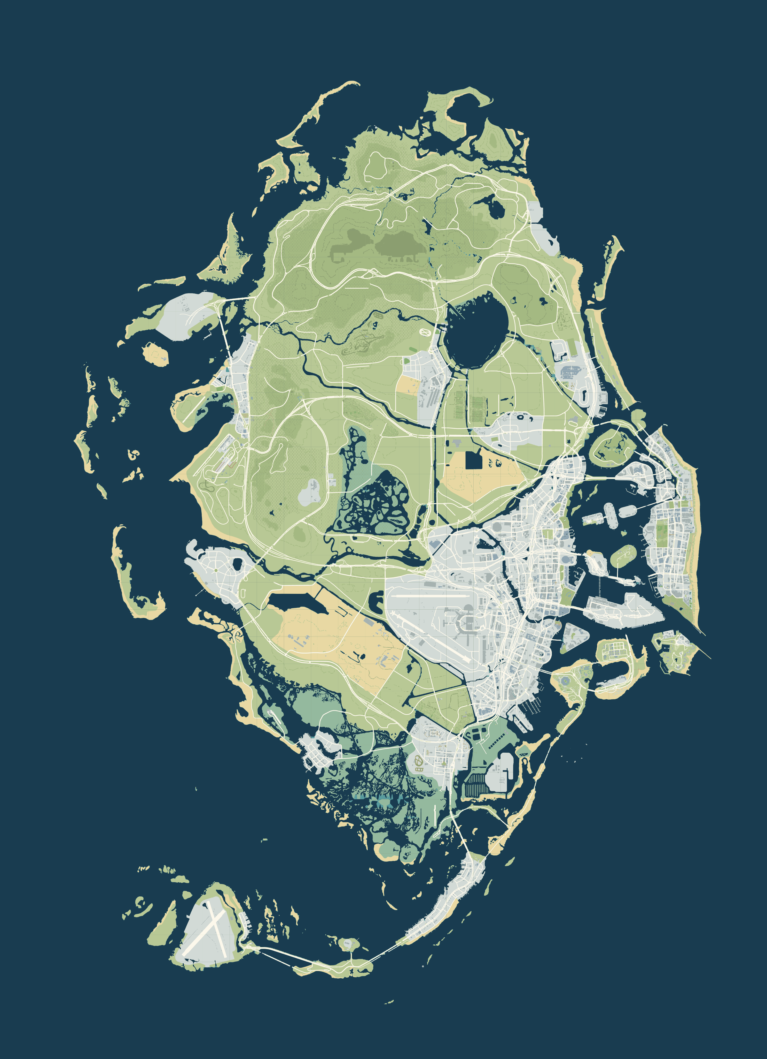
The map’s community layer shows the named places in GTA VI Landmarks Data, which GTADB.ORG publishes openly under CC BY 4.0. On the official poster, these additional positions are approximately registered using shared landmarks. Clean SVG and Community map use its original coordinates; the earlier atlas and terrain use separately adapted, approximate positions. Area references are representative centres, not boundaries. We removed names from the leaked material, generic and uncertain names and places our database already covers. Community places are labelled as such, link back to GTADB, and are not database entries. Where we haven’t reviewed a database entry’s position yet, its pin can use a labelled GTADB community position. Legacy illustration coordinates are never carried onto YANIS without a source position. A place joins the database only once two independent sources or an official artefact back it.
Basemap and coordinate review: November 19, 2026. YANIS v17 was published on October 17, 2026. Printed artwork, marker positions and source evidence are checked separately. Markers are visual references, not surveyed game coordinates.Interstate 404 and Interstate 97 are documented from road signs; their full routes are still unresolved.